Description
Highlights
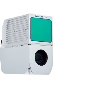
The AlphaAir 450 is designed for simplicity and precision, making advanced geospatial reality capture accessible to non-professional users and those new to the technology. At an affordable price, the AA450 combines ease-of-use with high-precision capabilities. This lightweight, durable solution integrates a high-performance laser scanner, a professional-grade 26 MP industrial camera, and a high-precision inertial navigation system to ensure superior data collection quality.
Achieve high-precision data with the integrated LIVOX AVIA laser scanner and 26 MP industrial camera. Obtain detailed and reliable geospatial data for various applications, from topographic mapping to emergency response.
Operate with simplicity using the AlphaAir 450’s intuitive design. Ideal for non-professional users, it enables efficient and accurate data collection without the need for extensive training
Operate confidently in various weather conditions with the IP64 rating, ensuring consistent performance and data quality, even in challenging environments.

Reviews
There are no reviews yet.